
Route Identity
Overseas Highway Ocean Bridge Scenic Drive
USA — Florida
Overview Layer
Overview
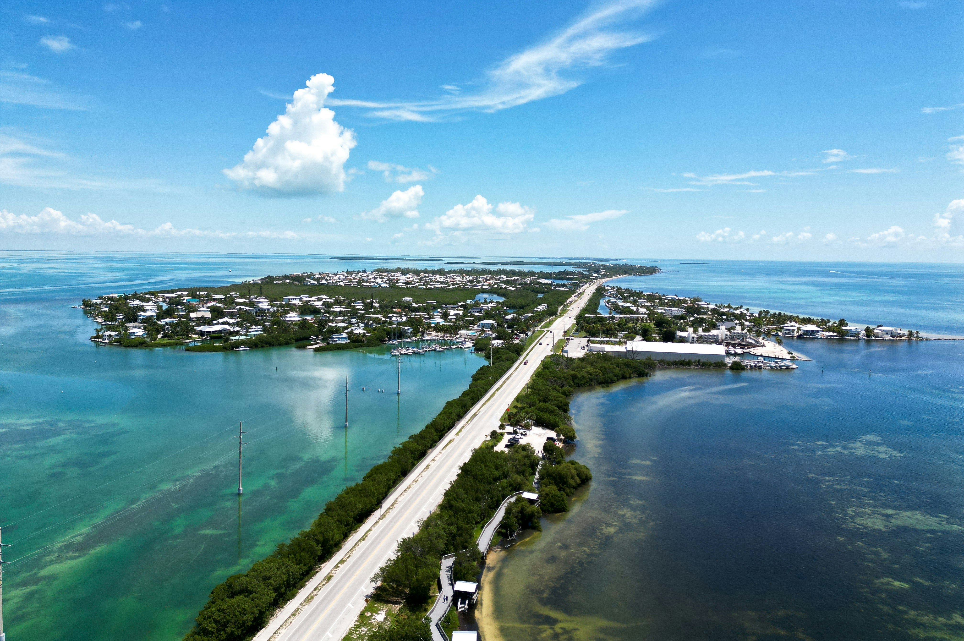
Experience the Overseas Highway, a unique road trip across the Florida Keys where long bridges connect tropical islands surrounded by turquoise waters and endless ocean views.
Weather
Tropical maritime climate with warm temperatures year-round and seasonal hurricane influence.
Seasonal Driving Conditions
Warm and generally stable tropical conditions with moderate rainfall.
- stable warm temperatures
- moderate rainfall periods
Hot, humid conditions with high precipitation and hurricane risk in late season.
- high humidity
- storm and hurricane season conditions
Gradual reduction in storm activity with still warm temperatures.
- gradual weather stabilization
- warm coastal air
Dry season with mild temperatures and lowest precipitation levels.
- dry season conditions
- stable road surfaces
Road conditions
Long bridge-connected highway over coastal waters with exposure to strong winds and storm surge risk during hurricanes.
Driving difficulty explained
Low to moderate difficulty with primary risks from weather events rather than road structure.
Route Snapshot Layer
Route Snapshot
This is a scenic driving route in Florida, USA.
The route features moderate driving conditions.
It is classified as Easy and is best suited for general road trip travelers.
Points of Interest
Attractions along the route
- African Queen — 42 m from route (20.7 km from start)
- The Laura Quinn Wild Bird Sanctuary — 84 m from route (30.5 km from start)
- Islamorada Train Caboose — 101 m from route (48.9 km from start)
- Captain Hook's Marina and Dive Center — 76 m from route (97.1 km from start)
Cafés and stops
- Starbucks — 37 m from route (46.2 km from start)
- The Lobster Shack — 11 m from route (186.3 km from start)
Places to eat
- Ma's Fish Camp — 31 m from route (50.7 km from start)
- Brutus restaurant & seafood market — 27 m from route (101.6 km from start)
- Florida Keys Steak And Lobster House — 14 m from route (104.4 km from start)
- El Habenero — 60 m from route (182.5 km from start)
Actual Driving Track (GPX-data)
Download GPXGPS Data Layer
Measured Driving Route
This route is analyzed directly from GPX track data. It features a total distance of 186.6 km, with an elevation gain of 306 m.
Route Structure
| Type | Distance (km) | Elevation Gain (m) | Avg Gradient (%) |
|---|---|---|---|
| flat | 186.55 km | 306 m | 0% |
About this route
The Overseas Highway Ocean Bridge Scenic Drive is one of the most scenic driving experiences in USA. Located in Florida, this route offers a unique combination of landscapes, road conditions and natural highlights.
Stretching over 186.6 km, this drive takes approximately 4 hours.
This route is especially popular among travelers looking for road trips.
Travel Experience
The strange thing about this drive is that it almost doesn't feel like driving through land at all. For long stretches there's water on both sides and sometimes it feels like the road is just floating across the ocean. It has a completely different atmosphere from mainland highways.
We kept noticing how many different shades of blue the water had depending on the depth and the sunlight. Every bridge seemed to offer a slightly different view. Even after a couple of hours it never really got old.
Traffic wasn't especially fast and nobody seemed to be in a hurry. People were pulling into marinas, small beaches and roadside restaurants all day. It felt more relaxed than most popular scenic routes.
There are plenty of places to stop, but we found ourselves spending more time simply driving than expected. Unlike mountain roads where every turn changes the scenery, here the appeal is the feeling of crossing island after island.
By the time we reached Key West, the destination almost felt secondary. The memorable part was the journey itself and the unusual experience of spending so much time surrounded by open water.
Best time to visit
The best time to explore the Overseas Highway Ocean Bridge Scenic Drive is typically during spring and summer months, when weather conditions are stable and visibility is high. However, autumn offers fewer crowds and more dramatic scenery.
Travel tips
- Monitor hurricane forecasts during summer and autumn
- Expect strong wind exposure on bridges
- Plan fuel stops due to long island stretches
Why visit
- Scenic landscapes unique to Florida
- Popular road trip destination in USA
- Great for photography
- Varied terrain and driving conditions
Driving Interpretation Layer
What this route means
How long is this route?
The route is approximately 186.6 km long, with an elevation gain of 306 m.
How difficult is the drive?
This route is classified as Easy, with a maximum gradient of 0.1%.
What kind of terrain does it have?
This is a relatively mild scenic route with steady and predictable driving conditions.
What makes this route unique?
The route combines elevation variation (306 m total gain) with changing landscapes shaped by natural geography and road conditions.
What type of driver is this route best suited for?
This route is suitable for most drivers, including casual travelers looking for a scenic and relaxed drive.
Discovery Layer
More routes in USA
About USA →
Blue Ridge Parkway Scenic Mountain Drive
Scenic mountain drive through the Appalachian Highlands.

Pacific Coast Highway Coastal Scenic Drive
Iconic coastal drive along California's Pacific coastline.
Utah National Parks Scenic Loop Drive
Arches, canyons and desert landscapes.
Dalton Highway Arctic Wilderness Drive
One of the most remote roads in North America.
Going-to-the-Sun Road Glacier Scenic Drive
High mountain road crossing Glacier National Park.
Beartooth Highway Alpine Scenic Drive
High alpine road with dramatic switchbacks.
More similar scenic routes
Pacific Coast Highway Coastal Scenic Drive
Iconic coastal drive along California's Pacific coastline.
Blue Ridge Parkway Scenic Mountain Drive
Scenic mountain drive through the Appalachian Highlands.
Great Ocean Scenic Coastal Drive
Coastal road famous for Twelve Apostles rock formations.
Utah National Parks Scenic Loop Drive
Arches, canyons and desert landscapes.
Going-to-the-Sun Road Glacier Scenic Drive
High mountain road crossing Glacier National Park.
Beartooth Highway Alpine Scenic Drive
High alpine road with dramatic switchbacks.