
Route Identity
Transalpina Scenic Drive – Romania’s Highest Mountain Road Through the Carpathians
Romania — Southern Carpathians
Overview Layer
Overview
The Transalpina Scenic Drive is Romania’s highest road and one of the most spectacular routes in the Carpathian Mountains. Reaching elevations above 2,100 meters, the road traverses open alpine terrain, high ridges, and sweeping mountain valleys. Often overshadowed by the famous Transfăgărășan, Transalpina offers a more expansive high-altitude driving experience with long panoramic sections and fewer settlements along the route.
Weather
Alpine continental climate with heavy snowfall in winter and short summer accessibility window at high elevations.
Seasonal Driving Conditions
Snowmelt period with partial road opening in high alpine sections.
- snow clearance operations
- partial road accessibility
Full accessibility of highest mountain road with stable conditions.
- full road opening period
- stable alpine driving conditions
Cooling temperatures with increasing precipitation and early closure risk.
- early snowfall risk
- reduced accessibility in high sections
Snow closure of high alpine sections.
- road closure in alpine zones
- heavy snow accumulation
Road conditions
High alpine road with steep gradients, switchbacks, and seasonal opening schedule depending on snow clearance.
Driving difficulty explained
High difficulty due to elevation, steep gradients, and weather dependency.
Route Snapshot Layer
Route Snapshot
This is a scenic driving route in Southern Carpathians, Romania.
The route features moderate driving conditions.
It is classified as Extreme and is best suited for general road trip travelers.
Points of Interest
Places to eat
- Mario Cafe — 30 m from route (0.0 km from start)
- Devis Bistro — 38 m from route (10.5 km from start)
- Alessia — 45 m from route (17.0 km from start)
- Cabana Oașa — 4 m from route (68.7 km from start)
- Popasul Mărginimii — 28 m from route (135.4 km from start)
Interesting stops
- Centru de informare turistica — 138 m from route (133.8 km from start)
Actual Driving Track (GPX-data)
Download GPXGPS Data Layer
Measured Driving Route
This route is analyzed directly from GPX track data. It features a total distance of 135.4 km, with an elevation gain of 3901 m.
Route Structure
| Type | Distance (km) | Elevation Gain (m) | Avg Gradient (%) |
|---|---|---|---|
| climb | 39.54 km | 2647 m | 6.4% |
| flat | 45.37 km | 784 m | -0.6% |
| descent | 50.45 km | 470 m | -4.4% |
About this route
The Transalpina Scenic Drive – Romania’s Highest Mountain Road Through the Carpathians is one of the most scenic driving experiences in Romania. Located in Southern Carpathians, this route offers a unique combination of landscapes, road conditions and natural highlights.
Stretching over 135.4 km, this drive takes approximately 3 hours.
This route is especially popular among travelers looking for road trips.
Travel Experience
The climb begins gradually through forests and rolling hills, giving little indication of how quickly the landscape will transform higher up.
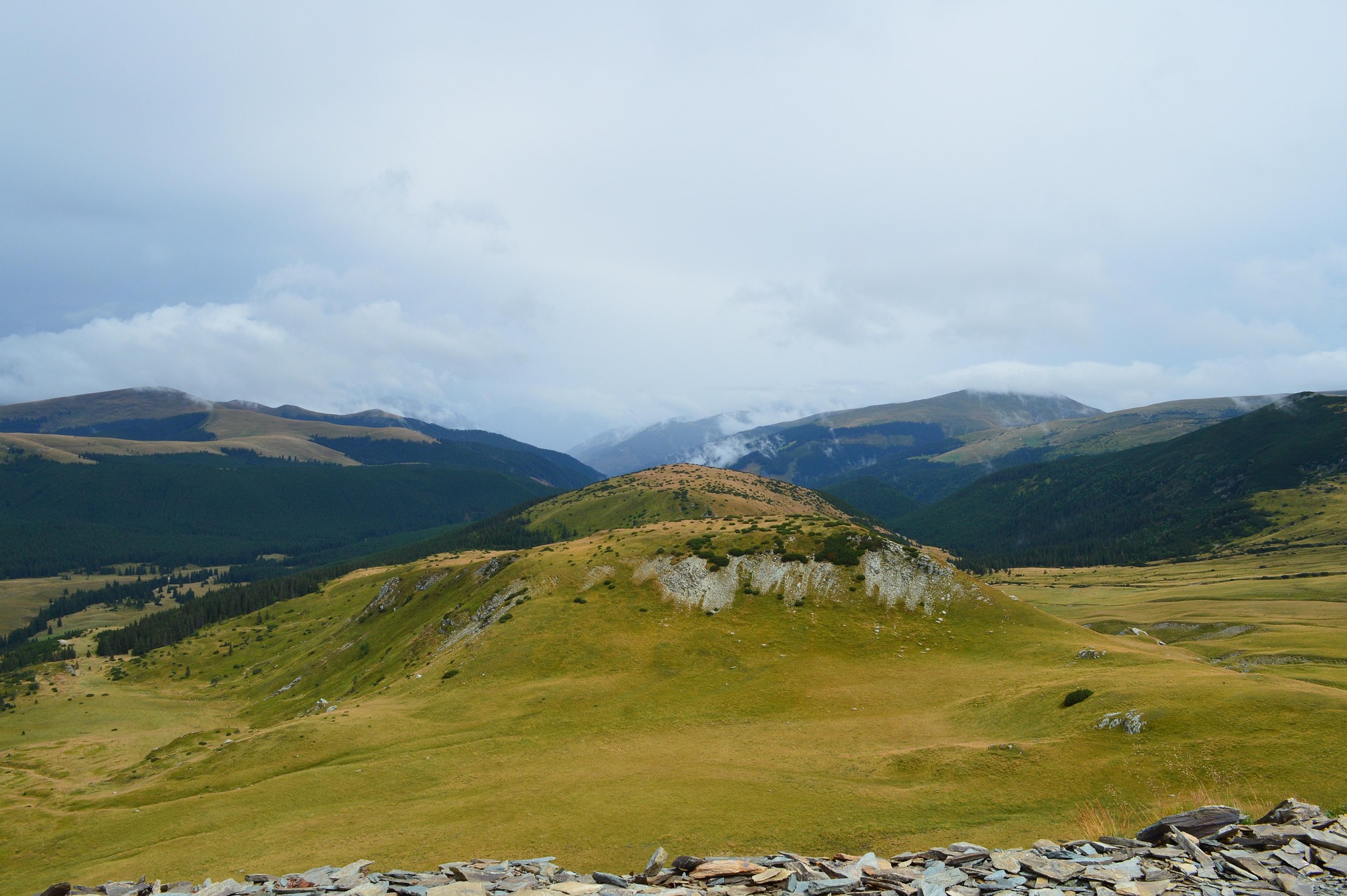
As the road gains elevation, the tree line eventually disappears and the route opens onto broad alpine slopes where the surrounding peaks seem to stretch endlessly in every direction.
Several viewpoints sit directly beside the road, making it easy to stop and appreciate just how high the route climbs above the valleys below.
Unlike many mountain roads that remain enclosed by cliffs, Transalpina often follows exposed ridges, creating a constant feeling of openness and distance.
By the end of the drive, the strongest memory is the sense of scale. The road feels less like a pass through the mountains and more like a journey across the roof of the Romanian Carpathians.
Best time to visit
The best time to explore the Transalpina Scenic Drive – Romania’s Highest Mountain Road Through the Carpathians is typically during spring and summer months, when weather conditions are stable and visibility is high. However, autumn offers fewer crowds and more dramatic scenery.
Travel tips
- Confirm seasonal opening dates
- Expect rapid weather changes in alpine zones
- Prepare for steep mountain driving
Why visit
- Scenic landscapes unique to Southern Carpathians
- Popular road trip destination in Romania
- Great for photography
- Varied terrain and driving conditions
Driving Interpretation Layer
What this route means
How long is this route?
The route is approximately 135.4 km long, with an elevation gain of 3901 m.
How difficult is the drive?
This route is classified as Extreme, with a maximum gradient of 10.3%.
What kind of terrain does it have?
This is a high alpine mountain route with significant elevation changes and exposed terrain.
What makes this route unique?
The route combines elevation variation (3901 m total gain) with changing landscapes shaped by natural geography and road conditions.
What type of driver is this route best suited for?
This route is best suited for experienced drivers comfortable with steep gradients, narrow mountain roads, and changing weather conditions.
Discovery Layer
More routes in Romania
About Romania →
More similar scenic routes
Apuseni Mountains Scenic Drive
Forests, caves and rural mountain roads.
Ukrainian Carpathians Scenic Mountain Drive
Green mountains, villages and winding roads.
Troyan Pass & Balkan Mountains Scenic Drive – Crossing the Heart of Bulgaria
Classic Balkan mountain drive featuring Troyan Pass, forested slopes, panoramic ridges and traditional Bulgarian villages
Bieszczady National Park Scenic Loop Drive – Remote Carpathian Wilderness Experience
Quiet loop through Poland’s wild southeastern mountains, forest valleys and remote Carpathian landscapes