
Route Identity
Nockalm Scenic Alpine Loop Drive
Austria — Carinthia
Overview Layer
Overview
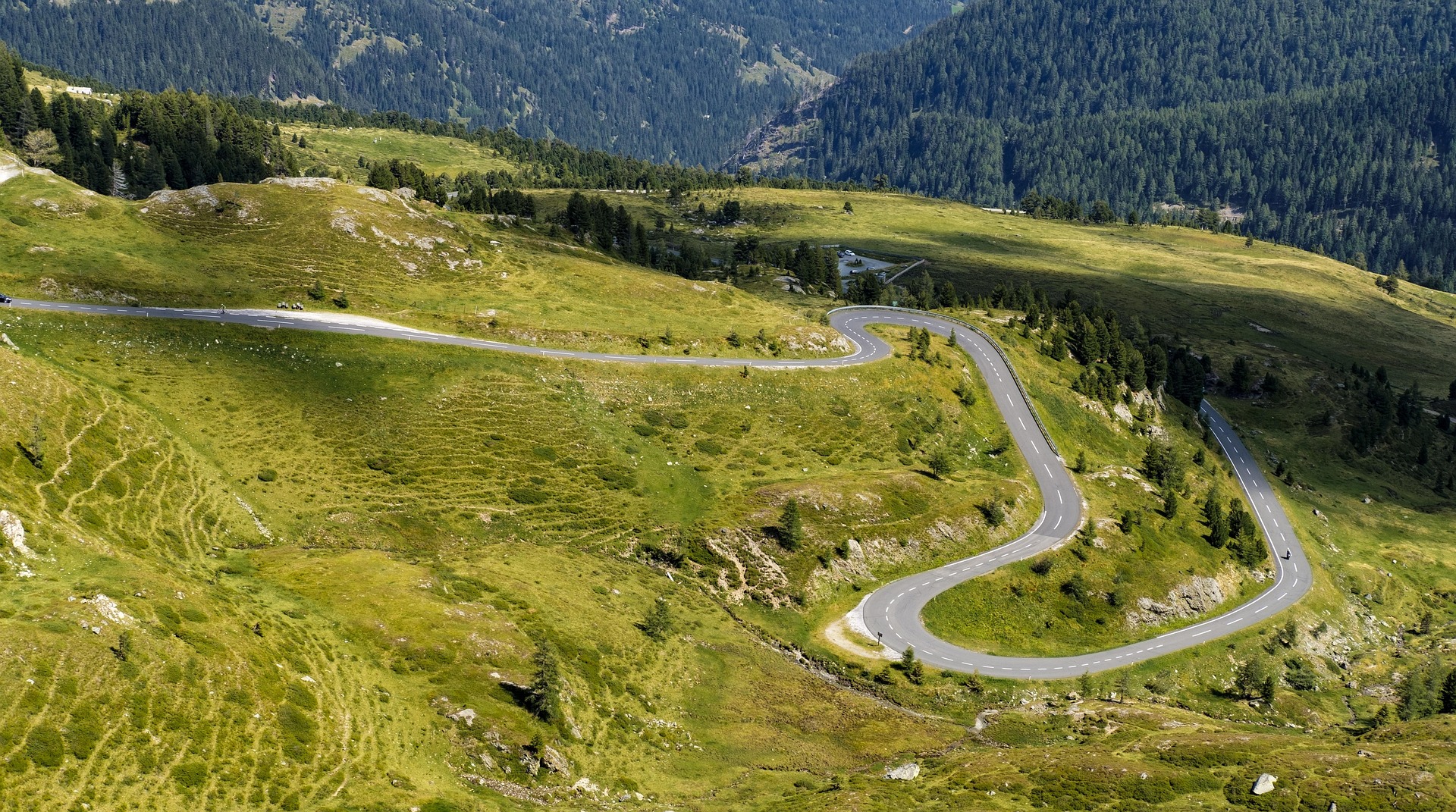
The Nockalm Road in Austria is a scenic alpine toll road in Carinthia, known for its smoother, rolling mountain landscapes compared to more dramatic alpine passes. The route winds through the Nockberge Biosphere Reserve, offering forested sections, gentle peaks, and quiet viewpoints without extreme hairpins or heavy traffic.
Weather
Alpine mountain climate with strong seasonal snow, short summer window, and winter road closure.
Seasonal Driving Conditions
Late reopening season with remaining snow patches and cool alpine conditions.
- snow clearance phase
- variable traction in high sections
Stable alpine weather with mild temperatures and fully open mountain roads.
- fully open road
- stable alpine driving conditions
Cooling temperatures with early snow risk at higher elevations.
- early snowfall risk
- cool temperatures
Closed due to heavy snow accumulation and alpine winter conditions.
- road closure
- snow-covered alpine terrain
Road conditions
High alpine scenic road with smooth pavement, switchbacks, and seasonal closure during winter.
Driving difficulty explained
Moderate difficulty due to altitude and seasonal weather changes.
Route Snapshot Layer
Route Snapshot
This is a scenic driving route in Carinthia, Austria.
The route features moderate driving conditions.
It is classified as Hard and is best suited for general road trip travelers.
Points of Interest
Places to eat
- Priesshütte — 115 m from route (8.1 km from start)
- Glockenhütte — 17 m from route (12.1 km from start)
Attractions along the route
- Feuerwehrmuseum — 1.6 km from route (0.0 km from start)
Actual Driving Track (GPX-data)
Download GPXGPS Data Layer
Measured Driving Route
This route is analyzed directly from GPX track data. It features a total distance of 12.1 km, with an elevation gain of 885 m.
Route Structure
| Type | Distance (km) | Elevation Gain (m) | Avg Gradient (%) |
|---|---|---|---|
| climb | 12.15 km | 885 m | 7.3% |
About this route
The Nockalm Scenic Alpine Loop Drive is one of the most scenic driving experiences in Austria. Located in Carinthia, this route offers a unique combination of landscapes, road conditions and natural highlights.
Stretching over 12.1 km, this drive takes approximately 1 hours.
This route is especially popular among travelers looking for road trips.
Travel Experience
We entered the toll road not really expecting much intensity, and it immediately felt calmer than other alpine drives we had done before.
At one small parking area there were just a couple of cars and a few people walking slowly around without much urgency. We got out mostly because everyone else did, then got back in fairly quickly.
There were long stretches where the road just followed gentle curves through forest and open alpine meadows. We didn’t really talk much, just drove without needing to concentrate too hard.
We stopped for a short break at a hut-style café that felt very quiet, almost empty. Nothing special happened, just sitting outside for a bit and watching the road.
By the end of the Nockalm Road, it felt like a softer version of an alpine pass, where the scenery was steady and consistent rather than dramatic or overwhelming.
Best time to visit
The best time to explore the Nockalm Scenic Alpine Loop Drive is typically during spring and summer months, when weather conditions are stable and visibility is high. However, autumn offers fewer crowds and more dramatic scenery.
Travel tips
- Check official opening dates before travel
- Expect rapid weather changes at altitude
- Use caution on steep mountain curves
Why visit
- Scenic landscapes unique to Carinthia
- Popular road trip destination in Austria
- Great for photography
- Varied terrain and driving conditions
Driving Interpretation Layer
What this route means
How long is this route?
The route is approximately 12.1 km long, with an elevation gain of 885 m.
How difficult is the drive?
This route is classified as Hard, with a maximum gradient of 10.1%.
What kind of terrain does it have?
This route features hilly terrain with several steep driving sections.
What makes this route unique?
The route combines elevation variation (885 m total gain) with changing landscapes shaped by natural geography and road conditions.
What type of driver is this route best suited for?
This route is best suited for experienced drivers comfortable with steep gradients, narrow mountain roads, and changing weather conditions.
Discovery Layer
More routes in Austria
About Austria →More similar scenic routes
Grossglockner High Alpine Scenic Road
One of Europe’s most famous alpine roads.
Silvretta High Alpine Scenic Pass Drive
Short but dramatic alpine toll road with hairpins, reservoirs and high mountain views

Route des Grandes Alpes Alpine Scenic Road Trip
High alpine route crossing multiple mountain passes.

Blue Ridge Parkway Scenic Mountain Drive
Scenic mountain drive through the Appalachian Highlands.
Garden Route Scenic Coastal Drive
Coastal drive through forests, lagoons and beaches.
Great Alpine Scenic Mountain Drive
Mountain road crossing Australian Alps.