
Route Identity
Kathmandu to Ramechhap (Manthali Airport) Epic Himalayan Scenic Transfer Drive Experience
Nepal — Bagmati Province
Overview Layer
Overview
The Kathmandu to Ramechhap (Manthali Airport) Scenic Mountain Drive is a key overland route in Nepal, often used as a transfer between Kathmandu and domestic flights to the Everest region. The road winds through steep Himalayan foothills, river valleys, and terraced hillsides, offering a constantly changing landscape shaped by elevation and rural life in central Nepal.
Weather
Subtropical highland climate influenced by monsoon patterns. Weather changes quickly with elevation, ranging from warm river valleys to cooler hill sections with seasonal rainfall dominance.
Seasonal Driving Conditions
Spring offers clear mountain views, blooming hillside vegetation, and generally stable road conditions across the Himalayan foothills.
- clear views of Himalayan foothills
- green terraced hillsides after winter dry season
Summer coincides with monsoon season, bringing heavy rainfall, reduced visibility, and slower travel times on mountain roads.
- monsoon-fed rivers running through deep valleys
- reduced visibility due to heavy rainfall and mist
Autumn provides the most stable and clear conditions with dry roads, crisp air, and excellent visibility across valleys and ridgelines.
- dry roads and stable driving conditions
- excellent visibility across layered mountain ridges
Winter brings cooler temperatures and generally dry conditions, though early morning fog can affect visibility in valley sections.
- cool, dry air in higher elevations
- morning fog settling in river valleys
Road conditions
Winding paved mountain road with frequent elevation changes, narrow valley sections, and occasional landslide-prone areas during heavy rain periods. Conditions are generally stable outside monsoon season.
Driving difficulty explained
Easy driving route overall, but with continuous elevation changes, narrow mountain roads, and increased caution required during monsoon season.
Route Snapshot Layer
Route Snapshot
This is a scenic driving route in Bagmati Province, Nepal.
The route features moderate driving conditions.
It is classified as Hard and is best suited for general road trip travelers.
Points of Interest
Attractions along the route
- Dhungedhara — 170 m from route (5.2 km from start)
Cafés and stops
- Underground Vojanalaya And Khaja Ghar — 18 m from route (20.5 km from start)
- Teahouse — 18 m from route (33.4 km from start)
Interesting stops
- Kalika hotel — 20 m from route (46.3 km from start)
- hotel Kritika — 14 m from route (47.0 km from start)
Places to eat
- Kwality Food Cafe — 33 m from route (0.6 km from start)
- Aasma Khaja Ghar — 32 m from route (0.9 km from start)
- Pizza Hut, Thimi Branch — 26 m from route (6.5 km from start)
Actual Driving Track (GPX-data)
Download GPXGPS Data Layer
Measured Driving Route
This route is analyzed directly from GPX track data. It features a total distance of 126.4 km, with an elevation gain of 3670 m.
Route Structure
| Type | Distance (km) | Elevation Gain (m) | Avg Gradient (%) |
|---|---|---|---|
| flat | 78.03 km | 1952 m | -0.5% |
| climb | 15.18 km | 933 m | 4.4% |
| descent | 33.18 km | 784 m | -3.5% |
About this route
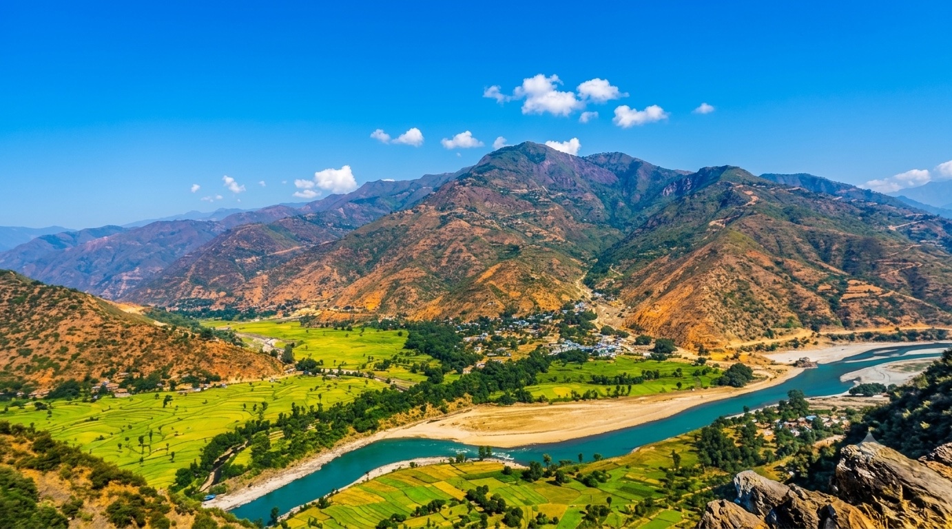
The Kathmandu to Ramechhap (Manthali Airport) Epic Himalayan Scenic Transfer Drive Experience is one of the most scenic driving experiences in Nepal. Located in Bagmati Province, this route offers a unique combination of landscapes, road conditions and natural highlights.
Stretching over 126.4 km, this drive takes approximately 3 hours.
This route is especially popular among travelers looking for road trips.
Travel Experience
Leaving Kathmandu, the traffic quickly fades into narrower mountain roads that immediately start climbing through surrounding hills.
The route constantly shifts between river valleys and ridgelines, making the elevation feel like it changes every few minutes rather than gradually.
Small villages appear along the road with terraced fields carved into steep slopes, where daily life happens just meters from passing traffic.
There are long stretches where the road follows the edge of deep valleys, and the scale of the Himalaya foothills becomes more obvious with every turn.
By the end of the drive, what stands out most is the intensity of the terrain — not extreme altitude, but the continuous rise and fall of the landscape packed into a relatively short distance.
Best time to visit
The best time to explore the Kathmandu to Ramechhap (Manthali Airport) Epic Himalayan Scenic Transfer Drive Experience is typically during spring and summer months, when weather conditions are stable and visibility is high. However, autumn offers fewer crowds and more dramatic scenery.
Travel tips
- Allow extra travel time during monsoon months due to slow road conditions
- Watch for fog in valley sections during early morning departures
- Expect frequent speed changes due to winding mountain terrain
- Keep flexible timing when connecting to airport flights
Why visit
- Scenic landscapes unique to Bagmati Province
- Popular road trip destination in Nepal
- Great for photography
- Varied terrain and driving conditions
Driving Interpretation Layer
What this route means
How long is this route?
The route is approximately 126.4 km long, with an elevation gain of 3670 m.
How difficult is the drive?
This route is classified as Hard, with a maximum gradient of 8.3%.
What kind of terrain does it have?
This route features hilly terrain with several steep driving sections.
What makes this route unique?
The route combines elevation variation (3670 m total gain) with changing landscapes shaped by natural geography and road conditions.
What type of driver is this route best suited for?
This route is suitable for confident drivers who are comfortable with occasional steep sections and mountain terrain.
Discovery Layer
More routes in Nepal
About Nepal →More similar scenic routes
Kathmandu–Pokhara Himalayan Scenic Drive
Mountain highway following river valleys between Nepal’s two most popular travel hubs

Route des Grandes Alpes Alpine Scenic Road Trip
High alpine route crossing multiple mountain passes.

Icefields Parkway Rocky Mountain Scenic Drive
One of the most scenic drives in the Canadian Rockies.

Blue Ridge Parkway Scenic Mountain Drive
Scenic mountain drive through the Appalachian Highlands.
Drakensberg Sani Pass Scenic Scenic Mountain Drive (Sani Pass → Lesotho entry)
Mountain drive along dramatic escarpments.
Great Alpine Scenic Mountain Drive
Mountain road crossing Australian Alps.