
Route Identity
Swedish Lapland Scenic Arctic Drive (E10 Highway Section)
Sweden — Lapland
Overview Layer
Overview
The Swedish King’s Trail Drive explores the remote landscapes of Swedish Lapland, passing through forests, lakes, and Arctic wilderness. This scenic route offers a peaceful driving experience and showcases some of northern Sweden’s most untouched natural scenery.
Weather
Subarctic and boreal climate with long winters and short mild summers.
Seasonal Driving Conditions
Cold conditions with snowmelt and wet rural roads.
- snowmelt runoff
- wet gravel roads
Mild subarctic weather with long daylight and best access.
- stable access period
- clear northern roads
Cooling temperatures with frost risk and wet forest roads.
- early frost conditions
- wet forest roads
Snow, ice, and limited daylight affecting driving conditions.
- snow-covered routes
- low visibility
Road conditions
Remote northern roads with forest sections and seasonal ice hazards.
Driving difficulty explained
Moderate difficulty due to remoteness and winter ice conditions.
Route Snapshot Layer
Route Snapshot
This is a scenic driving route in Lapland, Sweden.
The route features moderate driving conditions.
It is classified as Moderate and is best suited for general road trip travelers.
Points of Interest
Places to eat
- Annso Grillen — 74 m from route (104.5 km from start)
- Lilla huset — 112 m from route (105.7 km from start)
Interesting stops
- Preem — 60 m from route (105.1 km from start)
Attractions along the route
- Jättegrytor — 616 m from route (9.1 km from start)
- Jättegrytor — 571 m from route (9.1 km from start)
Actual Driving Track (GPX-data)
Download GPXGPS Data Layer
Measured Driving Route
This route is analyzed directly from GPX track data. It features a total distance of 291.3 km, with an elevation gain of 2487 m.
Route Structure
| Type | Distance (km) | Elevation Gain (m) | Avg Gradient (%) |
|---|---|---|---|
| flat | 245.25 km | 1877 m | 0.2% |
| descent | 26.84 km | 26 m | -3.1% |
| climb | 19.25 km | 583 m | 2.9% |
About this route
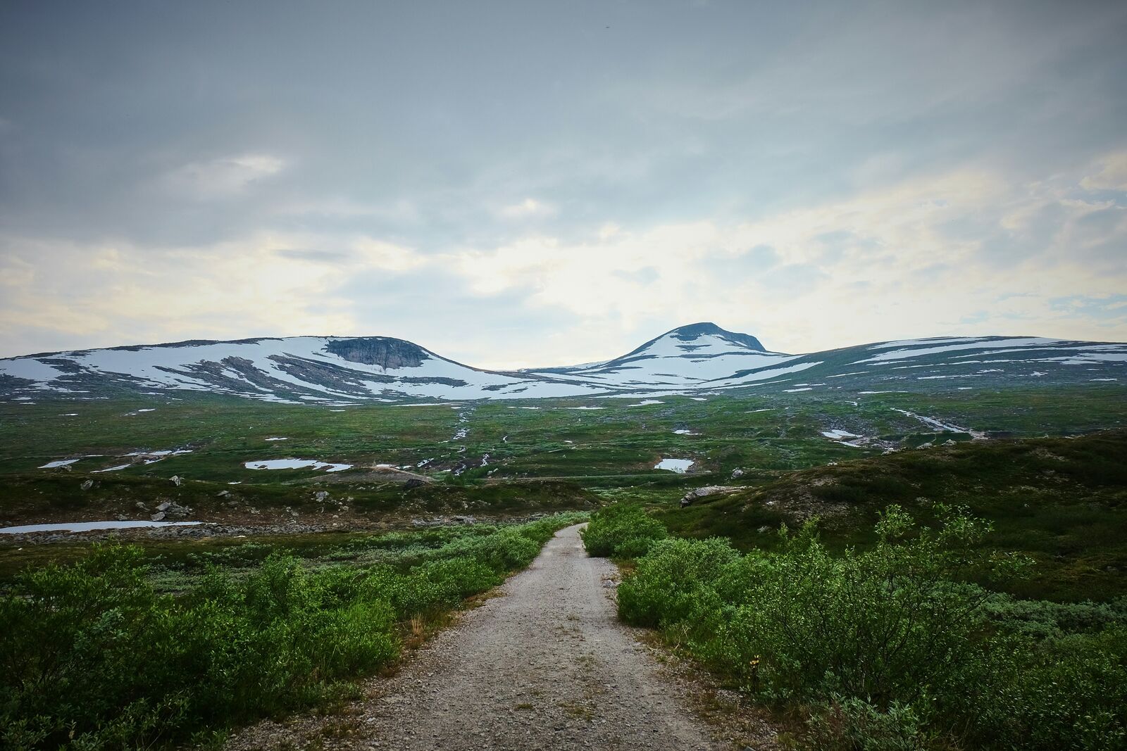
The Swedish Lapland Scenic Arctic Drive (E10 Highway Section) is one of the most scenic driving experiences in Sweden. Located in Lapland, this route offers a unique combination of landscapes, road conditions and natural highlights.
Stretching over 291.3 km, this drive takes approximately 6 hours.
This route is especially popular among travelers looking for road trips.
Travel Experience
We left in the morning but the light already felt soft, like it hadn’t fully decided what time of day it was. The first section was just forest and long straight roads with occasional signs pointing to lakes.
At one stop we pulled over near water because there was already a couple of cars there. People were mostly just standing quietly by the shore, not really doing anything specific, just taking a break and then leaving again.
There were long stretches where the Swedish King’s Trail Drive felt very repetitive in a calm way—trees on both sides, then an opening with a lake, then trees again. We didn’t talk much, just followed the road and occasionally slowed down for wildlife crossing signs.
We stopped for food in a small place that looked like it serves mostly travelers and locals passing through. It was warm inside and a bit too quiet, but that made it easier to sit longer than planned before getting back on the road.
By the end of the route, it felt less like a set of destinations and more like a long corridor of forest and water. The lakes were beautiful, but they came and went so naturally that none of them really felt like a final “stop,” just part of the same northern stretch.
Best time to visit
The best time to explore the Swedish Lapland Scenic Arctic Drive (E10 Highway Section) is typically during spring and summer months, when weather conditions are stable and visibility is high. However, autumn offers fewer crowds and more dramatic scenery.
Travel tips
- Prepare for long remote distances
- Check winter road status
- Expect limited services in northern areas
Why visit
- Scenic landscapes unique to Lapland
- Popular road trip destination in Sweden
- Great for photography
- Varied terrain and driving conditions
Driving Interpretation Layer
What this route means
How long is this route?
The route is approximately 291.3 km long, with an elevation gain of 2487 m.
How difficult is the drive?
This route is classified as Moderate, with a maximum gradient of 4.1%.
What kind of terrain does it have?
This is a relatively mild scenic route with steady and predictable driving conditions.
What makes this route unique?
The route combines elevation variation (2487 m total gain) with changing landscapes shaped by natural geography and road conditions.
What type of driver is this route best suited for?
This route is suitable for most drivers, including casual travelers looking for a scenic and relaxed drive.
More similar scenic routes

Icefields Parkway Rocky Mountain Scenic Drive
One of the most scenic drives in the Canadian Rockies.

Blue Ridge Parkway Scenic Mountain Drive
Scenic mountain drive through the Appalachian Highlands.
Garden Route Scenic Coastal Drive
Coastal drive through forests, lagoons and beaches.
Rila Lakes Scenic Mountain Loop Drive
Mountain lakes and alpine landscapes.
Lahemaa National Park Scenic Coastal Drive
Baltic forests and coastal scenery.
Apuseni Mountains Scenic Drive
Forests, caves and rural mountain roads.